The Stamford Historical Society Presents
Lost Streets of Stamford
An Exhibit
Introduction
by Thomas A. Zoubek, Ph.D., Executive Director, Stamford Historical Society
"Lost Streets of Stamford" illustrates a number of streets that were eliminated as part of the Urban Redevelopment of Stamford.
The first thought of redeveloping the downtown occurred shortly after the passage of Federal Urban Renewal legislation in 1949. The first concept model of a new downtown may have been that designed by 20-year old John Smith in 1952 while he was working as an assistant draftsman for the Planning Board. Discussion of the renewal of the downtown area began in earnest sometime around 1956/7 when Louis Greenbaum first initiated serious consideration of the idea. However, the City was already involved in the East Meadows Project on Jefferson Street and Federal monies were not available until that project was concluded. The Eisenhower administration also cut federal funds for renewal in the late 50s.
It was in 1959 that the City embarked on the search for a sponsor for the redevelopment of the southeast quadrant, an area bounded ultimately by River St, Broad Street, Elm Street and I-95.
By 1960 a sponsor would be selected: S. Pierre Bonan and F.D. Rich. No buildings were demolished until June 30, 1965, when 24 Willow Street was torn down. It was converted into a playground by mid July.
Because of court disputes and various delays the real building phase did not start until 1968/9 with the beginning of St. John's Towers, a moderate income housing project sponsored by the Diocese of Bridgeport through St. John's Parish. The first structure, built as part of the private construction of the Southeast Quadrant, was Landmark Square on Broad Street. Most of the structures in the exhibit continued to stand until well into the 1970s. During the 1970s and early 1980s most of the structures of the current downtown were built. An inner loop highway was constructed and the old grid pattern vanished, several streets disappearing entirely under the mall.
Doubtlessly, Stamford will continue to develop, but it is unlikely that the wholesale and at time traumatic clearing of the late 1960s and early 1970s will ever occur again.
URC Maps:
Section 1 Section 2 Section 3
LOST STREETS
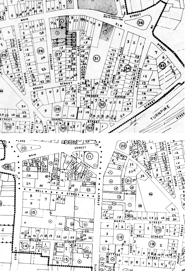
Map sections showing the streets in question

St. John’s Place
St. John’s Place first appears in the Stamford Directory of the year 1893/4. It is likely that nearly all the structures were built within a few years of the construction of the street itself. The street was closed and eliminated as part of the Urban Renewal of the Southeast Quarter.
Hawthorne Street
Hawthorne Street was a much older street than some of the others. It was first called Meadow Street and was put through sometime around 1850. It appears on the Beers Map of 1867 and subsequent maps. One of the first structures to be built on the upper part of the street (above I-95) was the original St. John’s Church and school, both wood frame structures that were long gone by the 1960s. Based on the Sanborn Fire Insurance Maps we can say with confidence that all the structures depicted in the photos were constructed prior to 1929, though some were clearly built much earlier based on their architectural style and a few appear on the 1879 City Map.
Tresser Avenue
Tresser Avenue (formerly School Street) originally was built off Meadow (later Hawthorne) Street some time around 1850. It was likely named for the Catholic school founded at the same time as the original St. John’s Church. It appears on the 1867 Beers Map. Most of the houses built on School Street date to the mid to late 1800’s.
Cottage Street
Cottage Street already existed before 1850. It appears on the Woodford Map of 1851. Some of the structures clearly date to the late 19th century. All the structures appear on the 1929 Sanborn Fire Insurance Map unless otherwise noted.
Chapel Street (north side near corner with Hawthorne)
All structures were built prior to 1929 and appear on that year’s Sanborn Fire Insurance Map, unless otherwise noted.
Holly Place
Holly Place first appears in the Stamford City Directory of 1914. It is likely that virtually all the houses were constructed prior to the end of WWI and all appear on the 1929 Sanborn Fire Insurance Map.
Willow Street
Willow Street was first constructed prior to 1850. It appears on the 1851 Woodford Map. Many of the structures were built in the 19th century.
This exhibit could not have been mounted without the work of the following people whom the Society thanks:
Ronald Marcus
Colin Skidmore
Mike Pastore
Robert N. Rich
The Urban Redevelopment Commission
Dr. Thomas A Zoubek
Maps and photos courtesy The City of Stamford, Connecticut, Urban Redevelopment Commission
Aditional images in the exhibit courtesy Robert N. Rich, F.D. Rich Co.
Photos also come from the Society's photographic collection and from scrap books donated to the Society by Pobie Johnston.
Related blog entry
Downtown Stamford Urban Renewal
Brownstones on Bell Street
Sanborn Fire Insurance Maps
Library of Congress Announces Digital Map Project
Pact with EDR Sanborn to Bring 1 Million Maps Online

